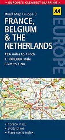
France Belgium & The Netherlands
Fully updated, AA Road Map France, Belgium & the Netherlandscombines clear design and an easy-to-read, 12.6 miles to 1 inch scale with more road detail to ensure that you never lose your way.
It also includes 8 city plans. Paris, Strasbourg, Luxembourg, Brussels, Den Haag, Amsterdam.
Also included is information on toll points, service areas, road numbers, motorways, dual carriageways and wide and narrow local roads, national parks, ski resorts, visitor attractions, towns and places of interest.
Presented in a practical, slimline format with a durable, weatherproof cover to protect it from the elements.
PRICE INCLUDES POSTAGE AND HANDLING

Connect with us...